This outstandingly beautiful walk covers a distance of approximately 1.5 miles (one hour) and begins at Tillington Village Hall where there is a car park. There are no steep climbs on the walk, but during the winter months some stretches may be rather muddy. You will see unsurpassed views of the South Downs and there is an ever changing natural flora throughout the area ranging from wild rhododendrons to tiny Scarlet Pimpernels. For clarity the walk is divided into two sections each with its own map and description. Clicking on the numbered circles will give a view at that point.
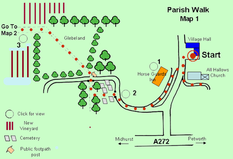
Parish Walk Map 1 (not to scale)
Leaving the car park turn left along the main road. A recommended diversion at this point is to visit the old Church of All Hallows with it's impressive Scots Crown surmounting the tower.
Return along the church path, cross the road and turn left on to the Causeway, which runs just beneath the Horse Guards Inn (1) (a splendid place for lunch or supper). Follow this round until it merges with Cemetery Lane and continue along this lane (west) as far as the Lychgate (2). Note the Old Manor House (14thC) on the left just before reaching the Lychgate.
Pass through the Lychgate into the Cemetery and follow the path to the bottom (snowdrops cover this area in late winter). Turn right along the tree-lined path to the brick arch (1863) and small wooden gate.
Cross directly over the lane on to the signed public footpath. Follow this path diagonally across the Glebeland, rising slightly to the top. Half way along turn to admire the church tower behind you. At the top of the path there is a newly planted vineyard, bear left along the track (west) when you will see magnificent uninterrupted views of the South Downs (3).
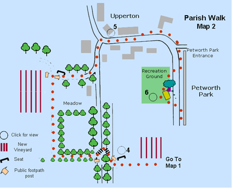
Parish Walk Map 2 (not to scale)
Continue along this track until you meet a small tarmac lane. There is a seat (4) at this point (0.5miles) where you can rest and enjoy the view.
Cross the lane diagonally,down some steps, to an old drover's road, and up the other side. Pass through a wooden gate and follow the track along the hedgerow (more stunning views). At the corner of the hedgerow turn right and continue up the footpath (north) as it rises between two meadows. At the top of this path you will see another seat and footpath sign (0.8 miles).
Turn right along the avenue of Whitebeam trees, continuing across the gravelled/tarmac drive until you meet the top of the old drover's road. Bear left up the hill when in approximately 100 yards you will find yourself in the centre of Upperton.
Bear right along the main street (note all the pretty cottages (5) in this area) as it descends towards Petworth Park. Soon you will see a footpath on the left on which to walk safely. After passing Park House you will see a small track on the left quickly leading down to an entrance into the Park. Continue along the path until you reach Tillington Recreation Ground. Cross over to this area, taking time to explore the splendid views (6) (and lots of seats and children's playground), or better still have a picnic (1.25 miles).
On leaving the Recreation Ground return to the footpath and descend into Tillington village with the old wall of Petworth Park on your left. Soon you will be able to see All Hallows Church once again, before arriving back at the Village Hall. As you arrive look at Park Terrace opposite, a row of charming Grade II listed cottages.
Click on image for larger picture
Click on image for larger picture